
Walk a Florence Street by Address
A reliable Florence street directory begins with the site, not a person. The Boone County PVA Property Search can accept a full address or just a road name. A road-name search is useful for gathering the parcels that front the same street. The public result is an assessment record, so its owner field should not be relabeled as a list of residents.
- Enter the street in Boone PVA. Save the site address, current assessed owner, and parcel identification number when shown.
- Open Boone County GIS. Match the address point, parcel shape, road centerline, ZIP layer, and nearby lots.
- Check the Kentucky voter channels only for the access the law permits. An individual uses the state lookup for their own registration; a qualifying requester uses the prescribed voter-file process.
- Search the owner in the Boone Clerk land index. Follow the current deed back through each grantor, meaning seller, and grantee, meaning buyer.
- For past people at the address, ask the Boone County Public Library archive desk about directories, newspapers, Family Files, and other dated sources.
This order keeps each claim tied to its source. The flow is address to parcel, parcel to owner, owner to deed, and dated publication to a possible occupant. When two lots use similar mailing text, the parcel number is the safer key.
Search Florence Roads in PVA
The PVA search separates address, parcel, owner, legal, and sales routes. Basic ownership and assessed value are free. Transfer history, photographs, property details, and some other fields are subscription features. Assessments reflect January 1 under Kentucky law, and the portal reported an August 22, 2026 update when researched. That makes the roll useful, but not live proof of who is present today.
| Search control | Input | Access | Best street use |
|---|---|---|---|
| ADDRESS | Full address or road name | Basic public search | Browse all returned parcels on one road |
| PARCEL ID | PIDN text | Basic public search | Confirm one GIS parcel without relying on spelling |
| OWNER | Last name, then first; no comma | Basic public search | Check other parcels held by the same named owner |
| LEGAL | Legal description | Subscription | Bridge an old number or subdivision lot |
| SALES SEARCH | Date, price, city, characteristics | Subscription | Study transfers across a Florence street |
The PVA office is in Burlington at 2950 Washington Street and can be reached at 859-334-2181 or pva@boonecountyky.org. That counter is a useful fallback when a parcel result is unclear.
Place Florence Streets on the Grid
The city offers a dated, stable companion to the live map. The 2024 Florence Street Index assigns streets to an A through J and 1 through 10 grid. Achates Avenue, for example, appears at F-5 and F-6, running from Hopeful Church Road toward Kelley Drive. The grid gives a citation-friendly location even when a dynamic map changes.
Then move to the county layers. The Boone address-point service exposes a site address, sub-address, number, prefix, street name, feature ID, and PIDN. The street-centerline layer adds labels, intersections, county-side fields, public-works identifiers, and several road classes. A street directory becomes much more precise when the grid square, street label, and PIDN all agree.
The manifest capture of the Boone GIS address-point fields shows the field-level source used in that match.
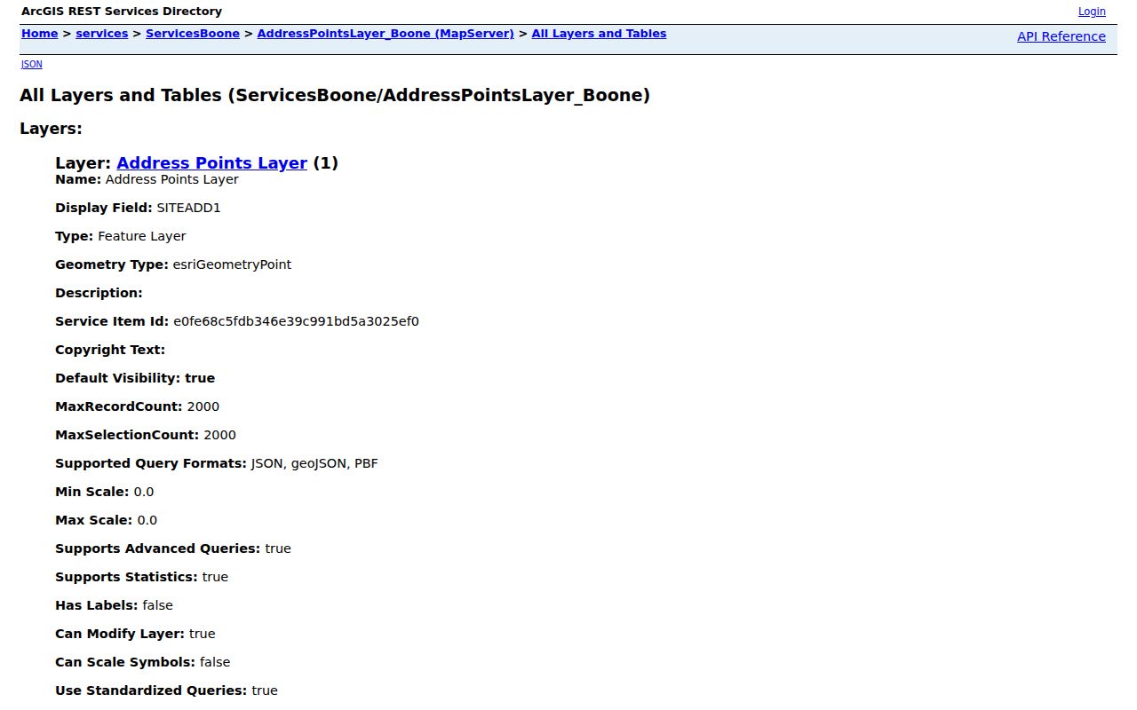
The field list helps separate a mapped site label from a verified household claim.
Florence Records Indexed by Address
Several Florence records can share a street name while answering distinct questions. The following coverage table keeps those roles apart and shows the fallback when the online tool is incomplete.
| Address record | Official keeper | What it can show | Channel and limit |
|---|---|---|---|
| Assessment parcel | Boone PVA | Assessed owner, value, parcel and address fields | Basic web search; office help in Burlington |
| Parcel and address point | Boone GIS | PIDN, lot shape, site address, ZIP and map layers | Viewer or REST query; 2,000-record selection limit |
| Land instrument | Boone County Clerk | Parties, date, book/page and legal description | eCCLIX, scanned books, or full counter |
| Permit report | Boone Building Department | Permit type, address, lot, project and jurisdiction | Online engine and dated reports; not every permit is listed |
| Code final order | Florence Code Board | Public address, case dates, action and named parties | Posted material or a focused city records request |
| Historical trace | BCPL archive | Published people, old address forms and dated notices | Digital archive, phone, email, appointment or shelf |
The same street may also appear in a tax list or election map. A full voter file has statutory limits and a prescribed request form; the public individual lookup is not a street-browse directory.
Read Florence Parcel Map Keys
A map pin alone is weak evidence. Query the parcel and address-point layers, then retain the PIDN, feature ID, site address, and street components. The county GIS catalog includes parcel classes, lot lines, tax districts, ZIP codes, right-of-way, easement, and public-works layers. Its stated use is general planning, so a deed or survey remains the source for a legal boundary.
- Parcel
- A mapped tract used for assessment. One mailing address may relate to more than one parcel.
- Situs address
- The physical site address. It can differ from the owner's tax mailing address.
- Plat
- A recorded drawing of lots, roads, and easements. It helps connect a subdivision lot to a deed.
- Criss-cross directory
- A volume arranged by street or phone rather than surname. No named Florence run was confirmed online, so ask the archive desk.
The Boone street-centerline layer documents the mapped road fields behind a street-by-street search.
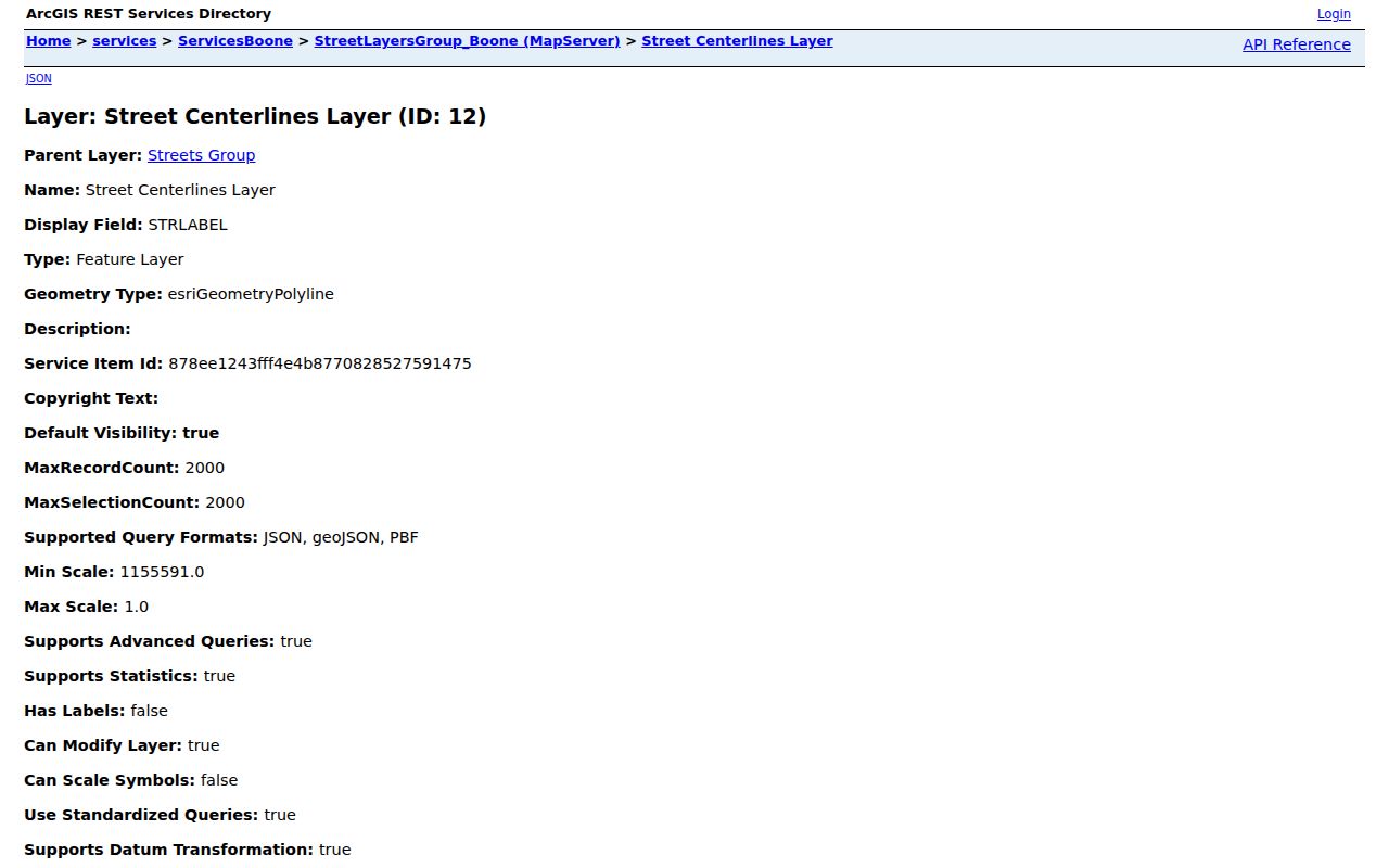
Using the centerline and address point together reduces errors from abbreviated or repeated street names.
Follow Florence Addresses Through Deeds
The Boone County Clerk Real Estate Department holds the recorded chain. Start with the current PVA owner, find that party as grantee in eCCLIX, save the deed book and page, and search the grantor as the prior owner. Repeat with the legal description and parcel clues. Deeds establish recorded interests, not every person who lived on the land.
The online cutover matters. Deeds D482 forward, beginning in 1992, are indexed. D170 through D481, covering 1965 through 1992, are scanned but not indexed. A name search that stops at the indexed line may miss an available image. Use the Clerk's record-room series chart, browse the image-only books, or visit the full Burlington counter. eCCLIX requires registered access and has account or payment controls.
Florence Streets Cross Other Lines
A Florence postal label, municipal boundary, ZIP polygon, precinct, and parcel district are separate geographies. ZIP 41022 is listed as a Florence post-office-box designation, while 41042 is the standard Florence label and includes Devon and Hopeful Heights aliases. Neither label alone proves that a site is within the incorporated city. Confirm it against Boone GIS and a city boundary source.
Boundary change records can explain why a street later appears in city files. A 2021 ordinance describes about 23.0348 acres near Weaver Road, Morgan Trace, and Saddlebrook. A 2020 city record describes about 2.735 acres at 6136 Hopeful Church Road. Use the legal exhibits and parcel geometry, rather than assuming that the full road entered Florence at once.
Note: Keep the legal city, postal ZIP, and election geography as three separate fields in every Florence street research log.
Bridge Old Florence Street Numbers
No official citywide Florence renumbering or renaming list was found. That gap calls for a careful chain, not a guessed match. Begin with the modern legal description and subdivision lot. Compare it with older deeds, the dated street index, permit reports, newspaper notices, and any directory page that can be tied to a year.
Older descriptions may use Crossroads, a post office, a church, the Covington-Lexington Turnpike, a railroad-era reference, or Boone County rather than a modern Florence number. The turnpike was complete in 1836, and Florence became its first stagecoach stop out of Covington. These are useful search terms for historical material, but a shared place name does not establish an identical parcel.
For historical occupants, the BCPL local-history desk can check newspapers, yearbooks, Family Files, photographs, and shelf material. A dedicated Florence reverse-directory run was not visible in the public catalog, so ask with the exact street, number variants, and date span. The full historical shelf belongs on the Florence city directory page.
Request Unposted Florence Street Files
Not every address record has an online index. Boone permit guidance says the online engine does not list all permits, while monthly reports show fields such as permit number, date, type, address, lot, value, project, subdivision, and jurisdiction. Florence code cases may have a posted final order but not the full underlying file.
Use the Florence request-to-inspect form for a specific city record. State the street address, record type, responsible department, and date range. Kentucky Open Records Act requests must identify the record and include the requester's name and signature. Agencies generally respond within five working days or explain a delay. For county land documents, the Boone Clerk accepts open-record requests through its own channels, and the counter remains the better route for book-and-page research.
Choose the custodian before sending the request. City Clerk records cover ordinances, council material, and Florence code files. Boone Planning and Building holds county permit material. The PVA can explain a current assessment entry, but it cannot certify a deed. The Boone Clerk is the land-record custodian, and the Court Clerk handles judicial files. If an online page fails, call first and ask which identifier the office needs. A parcel ID, permit number, case number, deed book and page, or ordinance number can turn a broad address question into a record the staff can locate. Mail, email, in-person counter service, and the appropriate request form remain valid parts of the street search.
Limits of a Florence Street Directory
An assessed owner may live elsewhere. A mailing address may be a tax-contact address. A deed may name an entity, trustee, or former owner. GIS fields SITEOCC1 and SITEOCC2 can carry site or secondary occupancy labels, yet the county layer is not a complete list of people at an address. Likewise, a voter record has legal access rules and proves only the facts recorded for that registration.
Current household members, private phone numbers, utility customer details, protected addresses, and sealed material should not be inferred from a blank result. Kentucky Safe at Home participants can use a substitute address in public and voter records, subject to stated real-estate exceptions. The honest street directory labels every finding by source and date.
Lawful use. Use Florence address records for lawful personal research, property history, and civic questions. Never use them to stalk, harass, threaten, or harm anyone.